Keynote speakers
As we gear up for the 7th FIG Young Surveyors European Meeting (7YSEM), we are excited to highlight the crucial role of our key speakers. These distinguished experts, who will be announced soon, bring unparalleled insights and inspiration to our event.
Keynote speakers are instrumental in driving the success of our conference. They offer:
Inspiration: Sharing their journeys and achievements, our keynote speakers motivate young surveyors to pursue excellence and innovation.
Knowledge Sharing: With deep expertise, they provide cutting-edge information on the latest trends and advancements in the surveying field.
Networking: Attendees have the opportunity to connect with these leaders, fostering professional relationships and mentorship.
Thought Leadership: They shape discussions on current and future challenges, guiding attendees to think critically and creatively.
The event is proudly announcing the following keynote speakers:
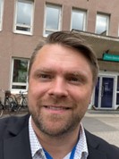 Miika Kostamo Executive Director, GeoForum Finland |
Executive Director, GeoForum Finland, https://geoforum.fi/english/ University Lecturer and Member of Advisory Board, Metropolia University of Applied Sciences, https://www.metropolia.fi/en
Vice President and CLGE representative, Finnish Association of Geodetic and Land Surveyors, https://milry.fi/briefly-in-english/ (Finland). Miika is a land surveyor, who started his surveying career in the city of Vantaa over 20 years ago and since has participated in over 100 surveying projects around the world. His surveying experience ranges from BIM-based building and infrastructure projects to nationwide aerial mapping campaigns. During the last 10 years he has also been involved in BIM and GIS standards development in buildingSMART, ISO and CEN. In his current work he is managing a geospatial collaboration network in Finland, which is a part of the European Digital Innovation Hub Network, through partnership in the Location Innovation Hub project, and member of EUROGI and GI Norden. Miika has also worked as a lecturer in Metropolia University of Applied Science for the last 14 years, where he has also received his Master's degree in land surveying. In Addition to this he also has a Master's degree in international business with emphasis on digital business opportunities. |
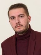 Prof.Habil.PhD.eng. Prof.Habil.PhD.eng.Tudor Sălăgean Dean of Faculty of Forest and Cadastre, University of Agricultural Sciences and Veterinary Medicine Cluj-Napoca (Romania) |
Tudor Salagean is the Dean of the Faculty of Forestry and Cadastre from USAMV Cluj-Napoca, Vice-President of the Romanian Surveyors Union and associate member of the Academy of Technical Sciences from Romania. He is a PhD supervisor in the field of geodetic engineering. He participated in various professional training courses such as "University Leadership Program" organized by Harvard University, Graduate School of Education, "Success in Entrepreneurship Ecosystem Development Program" organized by Babson College etc. He established the first bachelor's program in the field of geodetic engineering taught in English in Romania. Over the years, the results of research activities have materialized through the publication of 49 scientific papers in ISI journals, 5 scientific books, 3 didactic manuals and 4 practical work guides. He was constantly concerned with the updating of the education plans for the bachelor's and master's programs within the Faculty of Forestry and Cadastre in correlation with the current needs of the labor market, being also an active supporter of the young surveyors in Romania. |
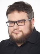 Postdoctoral Researcher Postdoctoral ResearcherWojciech Ostrowski Photogrammetry & Remote Sensing - Jagiellonian University, Warsaw University of Technology (Poland) |
He finished his studies in 2013 at the Warsaw University of Technology (geodesy and cartography - specialization: photogrammetry and remote sensing). He obtained his PhD at the same university, and his dissertation topic was photogrammetric processing of aerial oblique images. He is a licensed surveyor in the field of photogrammetry and remote sensing. He is an employee of the Faculty of Geodesy and Cartography at Warsaw University of Technology and the Institute of Archaeology at Jagiellonian University. His research interests include aerial photogrammetry (mainly oblique images for city modelling), UAV photogrammetry and laser scanning. He has been working (since 2011) on using unmanned aerial vehicles (UAVs) as photogrammetric platforms, including several R&D projects with Polish companies. His other research interests involve GIS and photogrammetry applications in archaeology. For more than a decade, he has been involved in the use of remote sensing technologies in archaeology. He has actively participated in national and international archaeological research projects (including UNESCO sites) during this time. He is a member of international organizations working at the intersection of archaeology and photogrammetry: Computer Applications and Quantitative Methods in Archaeology (CAA) and Aerial Archaeology Research Group (AARG). He took an active part in the creation of CENAGIS - an advanced IT infrastructure for research purposes, which was established at the Warsaw University of Technology as part of the project "Center for Scientific Geospatial Analysis, Satellite Computing along with laboratories for testing/certification of geomatics products" where now he is a leader in one of the laboratories. |